From Ground to Grid: How Precision Surveying Shapes Better Planning
Trio Planning Editorial
Principal Planning Consultant
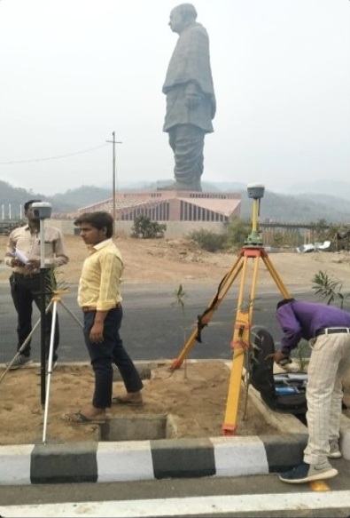
In any successful urban planning or infrastructure project, the foundation is not just conceptual—it is measured, verified, and grounded in reality. Before zoning maps, development proposals, or design interventions take shape, there is a critical stage that often goes unnoticed: field surveying and data acquisition.
This is where planning truly begins.
Understanding the Site Beyond Maps
While satellite imagery and secondary data provide a broad overview, they cannot replace on-ground verification. Field surveys allow planners to:
- Capture accurate topographical conditions — Mapping subtle terrain variations, slope profiles, and elevation changes.
- Identify existing land use patterns — Documenting actual ground occupancy versus official cadastral records.
- Record physical constraints and opportunities — Identifying natural drainage channels, utility corridors, and structural encumbrances.
- Understand human activity and movement — Observing pedestrian flows, vehicular access points, and localized community behavior.
The process involves systematic measurement using tools such as measuring tapes, leveling instruments, GPS devices, and marking systems to ensure spatial accuracy.
The Role of Precision in Surveying
Even a small deviation in measurement can lead to significant discrepancies in planning outputs. That’s why precision becomes critical.
From marking reference points to aligning axes and measuring distances, every step follows a structured methodology:
- Establishing control points — Setting benchmark monuments using Differential GPS (DGPS) for high-accuracy geo-referencing.
- Setting up reference axes — Orienting Total Station instruments to establish baseline grid networks.
- Recording distances and angles — Executing precise horizontal and vertical angle observations.
- Cross-verifying measurements — Performing closure checks and field data reconciliation before post-processing.
This ensures that the data collected is reliable enough to support further stages like base map preparation and development planning.
Bridging Field Data with Digital Planning
Once the site data is collected, it is translated into digital formats using GIS and CAD tools. This transformation enables:
- Creation of accurate base maps — Vectorizing field observations into layered CAD drawings.
- Layering of infrastructure and land-use data — Integrating utility pipelines, road rights-of-way, and Existing Land Use (ELU).
- Analysis for zoning and development proposals — Evaluating slope suitability, flood risks, and floor area ratios.
- Integration into regional and development plans — Direct translation into Town Planning (TP) schemes and Masterplans.
This step connects the physical site with analytical planning tools, allowing for informed decision-making.
Why It Matters for Urban Development
Accurate surveying is not just a technical exercise—it directly impacts:
- Infrastructure alignment — Preventing costly retrofits during water, sewer, or road construction.
- Land parceling and TP schemes — Ensuring equitable plot reallocation and smooth municipal approvals.
- Environmental planning — Safeguarding natural waterbodies, green belts, and sensitive eco-zones.
- Cost efficiency and feasibility — Minimizing project risk and budget overruns through verified ground truth.
In rapidly growing regions, especially peri-urban and developing zones, reliable ground data ensures that planning proposals are both practical and implementable.